Unseasonably Cool and Less Humid August in Alabama
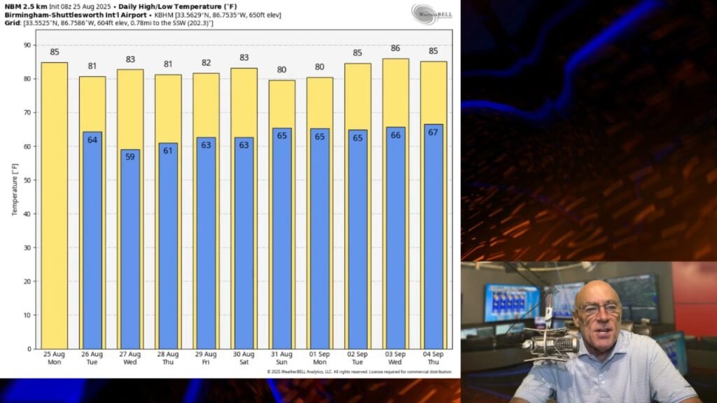
It’s pretty common for Alabama to experience sweltering temperatures in late August, but this year feels different. The typical patterns aren’t dictating the heat; instead, an upper trough in the eastern U.S. is doing the trick. This setup has pushed a cold front through late yesterday, with another one on its way. As a result, the humidity is lower, and we can expect cooler nights ahead.
The weather should stay fairly dry until Wednesday, although tomorrow might bring a few light sprinkles with the next front. Daytime highs will range from 78 to 84 degrees, and many areas in Northern Alabama could dip into the mid-50s by early Wednesday—like a sneak peek of fall!
Looking ahead, global models indicate that moisture will return with different surface fronts on Thursday and Friday, bringing light, scattered showers.
Weekend Outlook in Alabama
The surface front is likely to linger over the region, which means there’s a chance of showers and thunderstorms Saturday and Sunday. However, it doesn’t appear to be a complete washout—just the possibility of some rain here and there. Highs will generally hover around the mid-80s, so it may still feel pleasant.
Despite the chance of rain, temperatures are expected to remain below average.
Tropical Update
Tropical Storm Fernando is currently swirling in the Atlantic, about 360 miles northeast of Bermuda, with winds at 50 mph. It’s moving north-northeast at 20 mph and is expected to transition to a post-tropical system by tomorrow night—far from any land.
Another area to keep an eye on is the 99L investment near the Windward Islands. Over the last day, showers and thunderstorms associated with this tropical wave have decreased, and satellite data indicates that wind activity has weakened as well. Conditions are turning less favorable for development, with the National Hurricane Center estimating only a 10% chance it could strengthen further.
No tropical storms or hurricanes are anticipated along the Gulf Coast for at least the next ten days, which is some good news.
Football Weather
With college football season back in full swing, UAB will host Alabama at the Protective Stadium this Thursday at 7:30 p.m. CT. There’s a slight chance of rain during the game, and temperatures will drop from around 78 degrees to the low 70s by the fourth quarter.
Auburn is gearing up for a Friday night match against Baylor in Waco, Texas, with a 7 p.m. kickoff. Expect temperatures to start near 89 degrees but to cool down into the 80s.
On Saturday, Alabama will face off against Florida State in Tallahassee at 2:30 p.m. The weather might be a bit cloudier, with occasional passing showers and storms expected during the game, and temperatures will settle in the mid-80s.
Looking Back: August 2005
On this date in 2005, Hurricane Katrina made landfall in southeastern Florida as a Category 1 hurricane with 80 mph winds. It moved northwest on August 28, briefly reaching Category 5 status before diminishing to Category 3 just before making landfall along the North Gulf Coast on August 29.


