Audio of the article was made possible by the CAST11 Prescott Podcast Network. Production of Talking Glass Media. |
On March 21, 2023, an updated, finalized, and digitized map of the Oak Creek Floodplain will go into effect as part of a multi-agency effort to review flood risk along Oak Creek. As part of this effort, the city will invite the public to his virtual open house on March 1, 2023 at 6:30 pm to discuss these new maps. Future developments or insurance concerns refer to these effective maps.

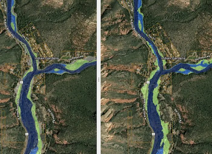
The flood map currently in use had to be updated because it had not been studied in detail for more than 30 years. Flood risk shown in current flood maps does not reflect the impact of subsequent growth. It also does not show changes in drainage or runoff patterns due to land use or natural forces.

In addition, more detailed information has become available and techniques related to mapping have improved. As a result, our updated flood maps more accurately represent these changes and current flood risk. This makes these updated flood maps an important tool for protecting life and property along Oak Creek.
access the map
To view the properties of previous and new flood maps to assess changes in risk, visit the following maps. https://tinyurl.com/Oak-Creek-Maps.
Virtual meeting details
The presentation will include sharing how property owners may be impacted, what options they have, and additional resources. Registration is not required. For the link to the meeting, www.coconino.az.gov/3060/Oak-Creek-Outreach-Watershed-Delineation.
A letter was mailed notifying the meeting to properties adjacent to Oak Creek within city limits with changes to the floodplain.
Background
Led by the Yavapai Flood Control District (YCFCD), they have worked closely with the Federal Emergency Management Agency (FEMA), the Coconino County Flood Control District (CCFCD), and the City of Sedona. The study included a tributary of Oak Creek from Stirling Canyon in Coconino County through the city of Sedona to Cornville, where it flows into the Verde River.
A partial flood map of Oak Creek in Yavapai County is still being finalized, but there will be only minor changes to what is shown in the map linked above and it is not expected to have a significant impact on floodplain restrictions. Please note that
For more information
If you have any questions, please contact the City of Sedona Assistant City Engineer at (928) 203-5076 or sphillips@SedonaAZ.gov.
Read more articles from The Mountain Cities at Signals A Z.com.