The National Weather Service issued a severe thunderstorm watch for Maricopa County effective July 25 at 3:25 p.m. The watch ends at 9:30 p.m. on July 25. The service also issued a flood watch in effect from 4:20 p.m. to 10:45 p.m.
Severe thunderstorms are located along a line from near Phoenix-Mesa Gateway Airport to Freestone Park, moving south at 10 mph. Wind gusts up to 60 mph and dime-sized hail are predicted.
Damage to roofs, exterior walls and trees is expected.
Affected locations include Mesa, Chandler, Gilbert, Tempe, Apache Junction, East Mesa, Queen Creek, Mesa Riverview Mall, Gilbert City Hall, Falcon Field Airport, Downtown Mesa, Tumbleweed Park, Ussary Mountain Park, Superstition Springs Mall and Chandler City Hall.
This includes the following highways: U.S. 60 between mile markers 177 and 201, State Route 87 between mile markers 164 and 180, and Loop 202 between mile markers 10 and 50.
The severe thunderstorms were located along a line stretching from near San Tan Mountain Park to six miles west of Blackwater near Casa Grande and were moving southeast at 20 mph, with wind gusts of 60 mph predicted.
Damage to roofs, exterior walls and trees is expected.
Affected locations include Mesa, Chandler, Gilbert, Casa Grande, Coolidge, Sun Lakes, Queen Creek, Blackwater, Chandler Heights, Tumbleweed Park, Magma, San Tan Village Mall, San Tan Valley, Seville and Bapture.
This includes the following highways: Interstate 10 between mile markers 168 and 194, State Route 87 between mile markers 132 and 164, and Loop 202 between mile markers 41 and 46.
The severe thunderstorms were located along a line stretching from six miles east of Wintersburg to seven miles west of Painted Rock Dam and near Sundad, and were moving southeast at 15 mph, with wind gusts of 60 mph and dime-sized hail predicted.
Damage to roofs, exterior walls and trees is expected.
Affected locations include Buckeye, Palo Verde, Painted Rock Dam, Liberty, Palo Verde Nuclear Generating Station, Sandad, Wintersburg, Hassayampa and Arlington.
This includes the following highways: Interstate 10 between mile markers 103 and 116, and Interstate 85 between mile markers 134 and 154.
The outflow of severe thunderstorms was along a line stretching from East Mesa to near Superstition Springs Mall and then to near Apache Junction and was moving southwest at 15 mph with predicted wind gusts of 60 mph.
Damage to roofs, exterior walls and trees is expected.
Affected locations included Mesa, Chandler, Gilbert, Apache Junction, East Mesa, Gold Canyon, Queen Creek, Chandler Heights, Gilbert City Hall, Tumbleweed Park, Ussary Mountain Park, Superstition Springs Mall, Chandler City Hall, San Tan Village Mall and San Tan Valley.
This includes the following highways: U.S. 60 between mile markers 182 and 203, State Route 87 between mile markers 165 and 169, and Loop 202 between mile markers 23 and 47.
The severe thunderstorm was located near the Palo Verde Nuclear Generating Station, or 12 miles southwest of Buckeye, and was moving southeast at 5 mph, with wind gusts of 60 mph and dime-sized hail predicted.
Damage to roofs, exterior walls and trees is expected.
Affected locations include Buckeye, Palo Verde, Painted Rock Dam, Palo Verde Nuclear Generating Station, Wintersburg, Hassayampa and Arlington.
This includes the following highways: Interstate 10 between mile markers 102 and 109, and Interstate 85 between mile markers 144 and 152.
Severe thunderstorms are located over Saguaro Lake, or 9 miles south of Sugarloaf Mountain, moving southeast at 5 mph. Wind gusts of 60 mph and dime-sized hail are predicted. Damage to roofs, siding and trees is expected.
Affected locations include Mesa, Apache Junction, Fountain Hills, Sugarloaf Mountain, Granite Leaf Dam, Gold Camp, Lost Dutchman State Park, Goldfield, Ussary Mountain Park, Saguaro Lake, Canyon Lake, Superstition Mountains, Goldfield Ranch, Kings Ranch and Salt River Tubing Recreation Area.
This includes the following highways: U.S. 60 between mile markers 192 and 202, State Route 87 between mile markers 187 and 204, and Loop 202 between mile markers 23 and 29.
A severe thunderstorm is located 11 miles northeast of Tonopah, moving southeast at 10 mph. Wind gusts of 60 mph and dime-sized hail are expected. Damage to roofs, siding and trees is expected.
Affected locations include Surprise and Buckeye, including Interstate 10 between mile markers 107 and 110.
Severe thunderstorms are also occurring near Wickenburg, moving southeast at 5 mph. Wind gusts of up to 60 mph and dime-sized hail are expected. Damage to roofs, siding and trees is expected.
Affected locations include Wickenburg, Whitman, Circle City and Morristown.
This includes the following highways: U.S. 60 between mile markers 107 and 128, and State Route 74 between mile markers 1 and 10.
Severe thunderstorms are also occurring near Roosevelt Dam or near Roosevelt, near stationary. Wind gusts of up to 60 mph and dime-sized hail are expected. Damage to roofs, siding and trees is expected.
Affected locations include Roosevelt, Roosevelt Estates, Roosevelt Dam, Apache Lake and Tonto National Monument.
This includes State Route 188 between mile markers 225 and 249.

Future Outlook:The 2024 monsoon season is turning out to be wetter than expected, so what kind of weather can we expect in Arizona in August?
For the latest warnings and alerts, Weather forecast page.

Tips for driving in the rain
Arizona Department of Transportation He offered the following safety tips for driving in the rain::
- Before rain is expected, check your windshield wipers and replace them if necessary.
- Please turn on your headlights.
- Please slow down.
- Do not brake suddenly on wet roads.
- Create a “space cushion” between your car and the car in front of you.
- Avoid areas with standing water in driving lanes.
Flood Weather Tips
Coconino County Officials They offered the following tips to residents to prepare for the approaching storm and potential flooding threat:
- To protect your property from flooding, purchase flood insurance.
- Make a plan for evacuation and shelter in place where you are.
- Please evacuate if advised to do so.
- Please evacuate to higher ground or stay on higher ground in case of flooding.
- Do not walk or drive through floodwaters. The depth and speed of water is not always apparent. Ground and roads can be washed away suddenly and hidden dangers may exist. Do not try to evacuate through floodwaters.
- Know how to avoid injury from debris, contaminated water, carbon monoxide poisoning, electrocution, and damaged buildings and infrastructure.
- Before entering a flooded building, have a professional check and inspect the building and facilities.
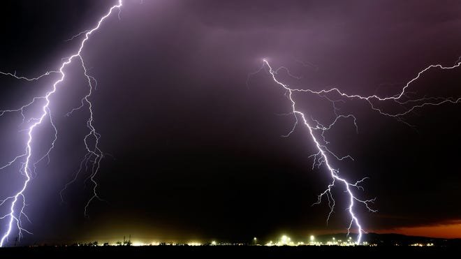
How to protect yourself from lightning
Here are some lightning safety tips from the National Weather Service:
- Pay attention to the weather: if you see big blue clouds, also known as thunderclouds, go indoors, as these clouds mean a thunderstorm is approaching.
- Stay inside a building that has plumbing and wiring. When lightning strikes a building, it travels around the building and strikes the ground.
- Stay in your car. This protects you from lightning as the electricity passes through the structure of the car instead of hitting you.
- Stay away from open water. Boats on the water are likely the most visible objects and may be hit.
- Do not shower or take a bath. If lightning strikes pipes, it could be conducted into the bath or shower water.
- Don't use any electrical appliances with plugs or cords – wireless cell phones are fine, as is a laptop that's connected to Wi-Fi but not plugged in.
- Follow the 30-30 rule: If you hear thunder within 30 seconds of a lightning strike, it means a thunderstorm is on the way. Wait at least 30 minutes after you hear the last thunder, so the storm has enough time to move away or dissipate.
- You don't have to be near a storm to be struck by lightning. Lightning can easily travel more than 10 miles. In 2007, a lightning strike recorded in Oklahoma traveled nearly 200 miles. If you hear thunder, take shelter.
- Don't take shelter under a tree, as if lightning strikes a tree, the ground charge from the lightning strike can be transferred to you.
- Stay away from close groups. If you're outdoors with friends or family during a thunderstorm, keep everyone apart. Keeping your distance will help reduce the number of people who get injured if lightning strikes.
This story was produced by The Arizona Republic and the USA TODAY Network using data released by the National Weather Service. Edited by staff.