Hot, dry, and windy weather continues to facilitate the spread of the Dragon Bravo Fire, which has now consumed over 100,000 acres and is only 9% contained.
What initially appeared as a slow-moving blaze on the northern edge of the Grand Canyon has transformed into one of Arizona’s largest wildfires this year. Lightning ignited the fire around July 4th. There was a brief period of monsoon moisture, but as conditions dried out again, the fire intensified significantly.
The prevailing weather conditions are primarily driving this rapid expansion and may keep posing challenges for containment efforts in the coming days. Humidity levels around Flagstaff have dropped unusually low for this time of year, as many states experience similar dry weather.
How Fire Weather Conditions Spread the Flames
At the fire’s onset, firefighters initially allowed it to burn for several days while they constructed containment lines. However, a shift in weather transformed the low-risk fire into a fast-moving threat.
The monsoon has been inconsistent, with small amounts of moisture followed by a quick return to dry weather.
“Since around July 16th, our humidity levels have started to show up, and we even saw a few light showers and thunderstorms,” noted a local meteorologist. “But the precipitation wasn’t sufficient to make a significant impact.”
Unfortunately, that brief increase in moisture was short-lived. Since July 22nd, the hot and dry conditions have returned, with humidity sometimes dipping into the teens or even single digits.
Much of Arizona remains entrenched in these dry patterns. The meteorologist pointed out that daytime humidity is often well below 15%, particularly affecting firefighting operations.
Wind is contributing to the issue; though not extreme, it complicates efforts to control the flames. Afternoon gusts have been around 20 mph, primarily coming from the southwest.
Is This Weather Normal During Monsoon Season?
Not really. While these conditions aren’t historically extreme, it is atypical for this time of year when Arizona typically enjoys higher humidity levels due to the monsoon.
“During the afternoon, humidity usually hovers around 30%, but right now, it’s dropping to about 10%,” the meteorologist explained.
It’s not impossible for this to happen, but such low atmospheric moisture is unusual. “We launch weather balloons in Flagstaff every morning to gauge moisture levels, and they’ve been historically low. By the end of July, moisture levels have hit record lows,” they added.
This deficiency in moisture has stifled storms and meaningful rainfall, especially near the fire.
Will the Rain Help?
As meteorologists keep an eye on the fire weather conditions, forecasts indicate that immediate relief isn’t on the horizon for firefighters. Predictions show little chance of rain for Friday, August 1st, and possibly early next week, which is discouraging, and could even introduce new risks.
“On Friday, we might see slightly higher humidity and a 10% chance of thunderstorms,” the meteorologist said. “With any luck, we could start seeing some monsoon moisture around Tuesday.”
Isolated showers and storms have the potential to be beneficial but also risky. “We’ll be fortunate to get rain on the fire, but that’s not something we can count on,” they mentioned.
Even if some rain does occur, it brings its own issues.
“It’s a double-edged sword. We want rain, but increased thunderstorm activity can pose dangers for firefighters,” the meteorologist cautioned. “Strong winds and lightning are serious concerns.”
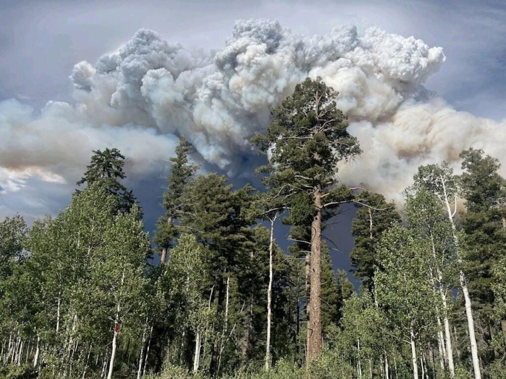
They’re also closely monitoring smoke columns from the fire, as intense heat can push smoke, ash, and moisture into the atmosphere.
These towering smoke pillars can become hazardous if they collapse, generating unpredictable winds at ground level.
For now, with dry conditions and high temperatures persisting, fire personnel are anticipating more challenging days ahead.